Research and text by Jenny Medd.
Part 1
Following the disastrous bushfire of February 2018, which burned across some 70% of the Mount Canobolas State Conservation Area, our NPWS Ranger and his colleagues welcomed assistance from local volunteers into planning for the recovery and future monitoring of this Reserve. This was partly as a result of reactions to a proposed development of dedicated mountain bike trails throughout the SCA, and largely due to the limited resources available to the NPWS.
It was apparent that little was recorded or collated in the public domain regarding the background history of the mountain complex. So began this attempt to trace the chronology of settlement and developments on and in the nearby surrounds of Mt Canobolas. Source material has been limited, with heavy use made of newspaper and government gazette searches on Trove and reference to digitised Historical Parish Maps of the area. It is an incomplete story and what follows is only a summary of the earliest parts.
Historical Parish Maps are also available on-line at https://hlrv.nswlrs.com.au/ and provide quite a good deal of information. The earliest accessible maps covering the Mount Canobolas complex are dated 1883 (1st ed.) for the parish of Towac;1884 (3rd ed.) for the Parish of Canobolas; 1895 (3rd ed.) for the Parish of Waldegrave and 1896 (2nd ed.) for the Parish of Orange. Newspaper articles collected from Trove go back to the early 1830s; however, research is confounded by spelling variations [Canobla / Conobla / Connobola] along with synonymous names for creeks in particular.
Probably the earliest official mapping of Mount Canobolas and the country to the east was carried out by Surveyor James Bryn Richards in 1828-29, the map now held in the NSW Archives Office (Map no. 1363). Richards records features labelled “Mt. Burranoor” (Mt Canobolas), “Guididega” (Young Man Canobolas), “Teouhuc” (Mt Towac) and an unnamed peak near the “Molong Rivulet” (Watts Pinnacle). A diagram of the ‘NSW Bathurst District Lands granted’, from 1829, identifies “Canoblas” on the western margin of the diagram – this is the earliest use of the name found in my research. In the same year, the name Blackman’s Swamp was first used for the village reserve that became Orange in 1846.
The story of local Aboriginal occupation, their use and management of the Mountain and its surrounds is sketchy, with little knowledge shared in the public domain, and early European reporting of Aboriginal culture and practices mostly suffering from a biased viewpoint. There is no doubt that many artefacts, unearthed since the days when Aboriginals lived freely in the district, have found their way into private collections as well as to the Australian Museum.
The 2019 Plan of Management for the Mt Canobolas State Conservation Area states ‘The cultural landscape of the park is part of the Country of the Wiradjuri People. The name Canobolas comes from the Wiradjuri words gaanha bulla meaning ‘two shoulders’, referring to the two main peaks, Old Man Canobolas (Mount Canobolas) and Young Man Canobolas. Mount Canobolas is a major Wiradjuri ceremonial site. Dreaming stories are known by some people with a strong traditional connection to Orange but these are not in the public domain.’
The first reported naming of the Range was back in 1815 when Assistant Government Surveyor, George Evans, sighted “high distant mountains to the north west” on Tuesday 23rd May, on his journey that day between Mount Lachlan (near Carcoar) and Lyndhurst. The highest peak, “one with a flat top”, he named Jamison’s Table Mountain. Anyone travelling between Bathurst (proclaimed on 7th May 1815) and the Wellington Valley (named by John Oxley in 1817) continued to skirt around the Canobolas Range.
It would appear that in the 1820s, W.C. Wentworth and Benjamin Boyd were among the first squatters at Boree (or Buree as it was first called), in an area outside the bounds of “civilized settlement”, the run later described as extending from Mt Canobolas and Borenore in the east to beyond Toogong in the west.
It wasn’t until 1835 that Major Thomas Mitchell, on his journey to explore the Darling River, records his ascent of the mountain on April 6th. While he is credited with the first ascent of the mountain, that should probably be amended to the “first notable European personality” to ascend. Undoubtedly, not only had the Aborigines roamed the mountain, but shepherds would have been tending flocks across the range for much of the previous decade.
Recent local histories record that “Boree Cabonne”, in the 1830s, was part of a tract of land leased by W.C. Wentworth and a Captain Raine. This is corroborated in the entry for Thomas Raine (1793-1860) in The Australian Dictionary of Biography which indicates his establishment of “Boree Station” followed the building of “Rainham” in Bathurst in 1832. “Mr Raine’s station at Boree” is also noted in an article in the Sydney Herald of Monday 18th August 1834. “Boree (or Buree) Station” was later sub-divided and the original homestead became “Boree Cabonne”. Major Mitchell’s 1836 expedition, as recorded in his diary notes, visited “Buree Station”, where Captain Raine was “to furnish oxen and sheep to complete my [Mitchell’s] commissariat supplies”.
In November 1841, a distinguished Englishman, John Hood, reported visiting his son Thomas, whose property was “14 miles from Boree, and the sheep runs extend to the towering top of the Connobolas”. At that time the Molong Rivulet divided the colony “from the wilderness which however, is settled by stockholders nearly two hundred miles further to the west. …and the Canobalas range was the haunt of bushrangers”. Hood also notes in his descriptions of the surrounding eucalypt forests that “many are charred and black in the stem, from the fires of the natives, and the conflagrations of the forest”. He records an extensive drought throughout the summer of 1841/42 and a major bushfire on Canobolas in late summer (mid-March perhaps), and comments that the eucalypts found on the slopes of the mountain, especially ironbark and stringybark, were “most useful to Europeans for timber and bark used in building, bush furniture and post and rail fencing”. These “pioneer days” are also referred to in an article in the Sydney Morning Herald in 1913 (Saturday 26th April, “The Old Man. Canoblas views”, by C.T.) suggesting “the country surrounding was [once] a dense forest, consisting largely of gigantic gums. Mobs of wild horses made tracks through the forest, and took refuge in the mountain gorges”.

During the 1850s the land west of Orange was steadily carved up. Prior to this, only annual “Licences to Depasture Stock beyond the limits of location” were granted. In 1850 Government Gazette notices listed numerous portions of Crown Land within the “settled districts” for lease by auction. The portions were still within the County of Wellington, parishes unnamed, some identified as “near the Canoblas” with boundaries often referenced to Molong Rivulet or Boreenore Creek.
Following gold discoveries in the region, geological surveys were carried out in 1851/52. Notable on the early Parish maps is the broad area of Crown Land dedicated to the “Cargo Gold Fields” which reached right across the western slopes of Mount Canobolas.
1861 saw the introduction of the Robertson Land Act which transformed land ownership in NSW. The long-established monopoly of the squatter-pastoralist ceased, with closer settlement of pastoral lands planned to increase farming and agricultural development.
In 1867 Surveyor Isaiah Rowland reportedly cleared the top of the main peak of timber – a plateau of about 10 acres – and the “County boundaries of Ashburnham, Wellington and Gordon were by him clearly defined by clay cuts and pegs. In later years another surveyor erected a cairn of stones on the summit. In the centre of the cairn is an upright post holding up two circular metal plates showing the exact direction of the county boundaries”. The article reporting this development also included the observation that “the Canoblas range in time of drought has been the pasture ground of many thousands of sheep”.
Water was always a prime consideration in the opening up of these western lands and Mount Canobolas was recognized as a water source very early on, with numerous springs identified on its slopes. In 1876 some 1,920 acres had been reserved on the south-eastern section of the mountain (in Towac Parish) where it was proposed to construct a dam for Orange’s water supply. An area on the western slope of the mountain’s peaks was reserved “For Recreation” in 1885. Together these two areas begin the evolution of today’s State Conservation Area.
At that time there were two steam sawmills operating, one on Mr Watt’s property, while the other was run by Smith and Plowman in Devil’s Hole.
Greater plans for the mountain were to follow.

Part of the Canobolas Parish Map of 26 August 1884 with ‘notes’ added until it was superseded on 7th January 1898. It shows the Recreation Reserve, the Cargo Gold Field, proclaimed on 7th September 1889, and the Boree Nyrang Run
Part 2
At the end of the 19th C, there was mixed interest in the area around Mt Canobolas. R.H. Cambage, a surveyor with the Department of Lands and Mines, conducted the first informal plant survey across western NSW in1899, including an ascent of the “Canoblas” mountain which he noted already held ‘intense geological interest’. The latter attracted much more attention than botanical pursuits and Father J. Milne Curran’s exploits and discoveries were widely reported, especially his discovery of “a petrified mass of insects and reptiles, including snakes, lizards, centipedes, scorpions and grubs, which are supposed to have lived a great many years ago”. Geological interest was always about potential mineral resources, with huge areas of crown land, particularly on the west and south-west slopes of the range, identified as potential “Gold Fields”.
30th December 1899 saw an application by the Orange District Federal Capital League suggesting an area of some 73,000 acres, the highest point within which was the Canoblas Mountain, for consideration as a site for the Federal Capital of Australia. Over the following 12 months numerous newspaper articles appeared on the subject, extolling the many values of the site, including the possession of building materials ranging from basalt blocks, granite, “superior” marble, flagstones (specifically from established “quarries on the Eastern slopes of the Canoblas Mountain”), hardwood timber, and clay of “a superior quality” for bricks. A significant collection of photographs was added to the stories in The Sydney Mail on Saturday 3rd and 10th November, 1900.

See the National Library website for extra pages: https://nla.gov.au/nla.obj-499942396/view?partId Photographs from The Sydney Mail and New South Wales Advertiser (NSW : 1871 – 1912) Sat 10 Nov 1900 Page 1114 THE FEDERAL CAPITAL QUESTION
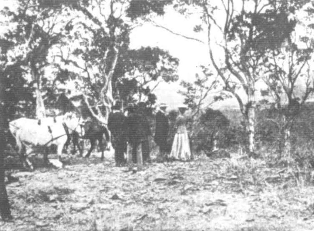
“First halt on the Canoblas”
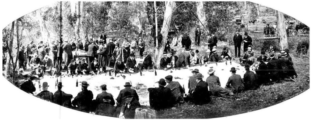
“Luncheon, Meadow Creek, Towac, Site of Proposed Water Scheme”
Local geology once again made the newspapers on Wednesday 13th March 1901, when the Daily Telegraph reported Father J. Milne Curran’s lecture on the “Geology of Canobolas”. While Curran speculated about “uncouth monsters [that] roamed over the hill” in ancient times, he also “showed that many rocks about Orange had been formed in the quiet depths of the ocean [and stated that] beautiful corals were now to be found on the slopes of Canobolas.” He also mentioned that “Under the basalt at Forest Reefs at the present time miners found “fossil nuts” but there are no trees to-day in Australia that bear such fruits.” [It would be fascinating to be able to re-visit his specimens and the lantern-slides he showed at that lecture.]
In 1902, 30 acres of land on the summit, within the then Recreation and Water Reserves was notified as Crown Land reserved for trigonometrical purpose.
1903 finally saw correspondence with the Public Works Department, Sydney regarding “A road to the old man” reported in the Leader (Orange) for Tuesday 19th May, 1903. J. Davis, Under Secretary advised that the Minister had “directed that the work be put in hand by contract” for the construction of “a track to the top of Canoblas mountain”. The Molong Express and Western District Advertiser, on Sat 15th April 1905 finally reported that “a road fit for vehicular traffic had been made right to the top of Mount Canoblas. From the camping place (which is about half a mile from the cairn) to the summit a new road has recently been surveyed and splendidly made with an easy grade all the way.”; this would have been today’s ‘Old Canobolas Road’.
The Sunday Times (Sydney) of 10th January, 1909, reported the first car to ascend the mountain, with Captain Philip Charley driven by his chauffeur over the “rough, steep, dangerous road” suffering “one puncture only”. This feat was not repeated for some time, with the Wellington Times finally announcing on Monday 7th November, 1910, that “Doctor N.R. Howse of Orange [had] succeeded in reaching the top of the Canoblas in his motor-car the other day. This is only the second occasion on which the feat has been accomplished”.
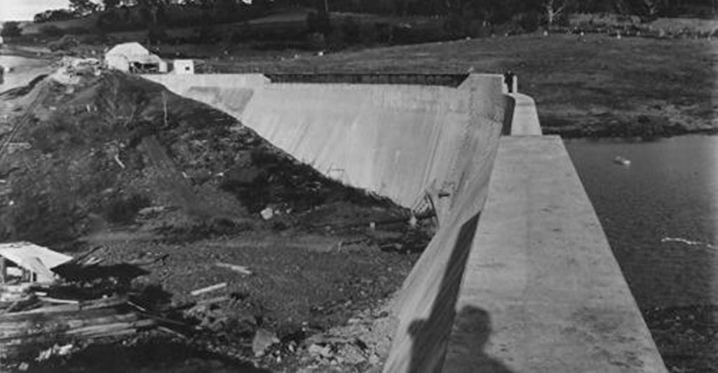
The mountain remained a prime water source over the years, with the main focus continuing to be on the Molong Rivulet or ‘Meadow Creek’, which begins its life today as Towac Creek. What is now Lake Canobolas was conceived back in 1915-17 as a supplementary water supply for Orange.
1933 saw one of the earliest sourced reports of fires on the mountain, although obviously not the first wildfire to occur there. A newspaper article from March 1933 describes bushfire raging across the local countryside, reportedly destroying “thousands of acres of country in the rugged hills to the south of Mount Canobolas” and moving across the “Canobolas Reservation” and adjacent properties.
The mid 1930s brought roadwork programs to the forefront with “works for the relief of unemployment” applied to improving access to the top of Mount Canobolas, principally with tourism in mind. By 1937, this would include not only continuing work on the summit roads, but construction of a road from the Pinnacle to Towac, and improvements to both Pinnacle and Towac reserves including “shelter sheds and conveniences”.
February 1938 saw both the new scenic road/drive over Mount Canobolas and a scenic drive from the Pinnacle to Mount Canobolas opened. The latter was officially named ‘The Alfred Stephen Scenic Drive’, marked by a plaque on the roadside opposite the Pinnacle Reserve, recognising the services of Alfred Stephen, the Canobolas Shire Engineer.

Although Canobolas Shire Council had announced intentions to secure both Mount Canobolas and The Pinnacle as public recreation reserves as early as 1926, it was not until 1944 that the proclamation reserving Mount Canobolas from sale for public recreation was declared (an annotation on the 1936 Towac Parish Map). In 1945 the Trust of the Mount Canobolas Recreation Reserve was formed to manage the reserve for recreational use and tourism potential while upholding “conservation objectives”.
During the 1940-1950s, a series of low intensity burns were apparently conducted by landholders across the mountain (noted in the 2003 Plan of Management for the reserve).
Continuing suggestions for activities and developments atop the mountain in the early years of the 20th C included the following:
- In 1903 the summit proved a great site for astronomical observations, with a Professor Hussey of the Lick Observatory at the University of California claiming to have “discovered 10 double stars previously unknown to astronomers”.
- In 1907 came the suggestion of that “the mighty Canoblas Range [be] utilized and developed and converted into what it ought to be – one of the principal pleasure and health resorts of Australia”.
- 1913 produced the idea for a “solar physics laboratory” on the summit.
- In 1927 the “dreams of establishing a solar observatory on the Mountain” re-surfaced in comment from Father Pigot, Science Master at Riverview, a “first and foremost scientist”.
- Shire Engineer, Alfred Stephen, in 1938 facilitated the construction of a ski run on the mountain, recorded as 150 yards from the summit, 100 yards wide and running for approximately half a mile. The Canobolas Ski Club formed the following year appears to have lapsed by 1947, having been only intermittently active in the years in between.
- 1938 was also the year that Country Broadcasting Services took up a lease on the peak, although reports of planning for the television transmitting station don’t appear until 1953.
- 1939 brought proposals for picnic and camping areas for a “tourist resort” in the Mount Canobolas Reserve.
The war years have unfortunately yielded little more than what is reported above. The story post World War II is to be continued….
Part 3
At the end of World War II, what we now know as Mount Canobolas State Conservation Area was still evolving from water reserves set aside as early as 1869: Reserve No. 71,339 (across Canobolas, Clarendon and Towac Parishes) had been gazetted for Public Recreation in November 1944, and the first Trustees appointed. On March 22nd, 1946 Mount Canobolas Reserve was proclaimed a Bird and Animal Sanctuary. An additional section, Reserve No. 74,964 (in Towac Parish) was gazetted for Public Recreation in April, 1952 (boundaries unable to be ascertained). It would appear that in February 1959, all the various portions “reserved from sale” were consolidated into Reserve 81412, the “Mount Canobolas Park”.
Meanwhile, the western slopes of the mountain steadily succumbed to pine plantations, with the Minister for Conservation approving the purchase in 1948 of 12,000 acres which would initially become the Canobolas State Forest. Land acquisition for forestry continued through the 1950s and 1960s, expanding to also create the adjacent Glenwood State Forest. Such early landmarks as “Captain Raine’s Springs” were subsumed in the process.
The plaque erected on the summit in 1949, instigated by the Orange and District Historical Society to record Major Mitchell’s ascent of the mountain back on April 6th 1835, has unfortunately been vandalised.
In the interim, suggestions for developments on the mountain continued.
- The local State Member in 1947, Mr O’Halloran, envisioned a tourist chalet at the top of the mountain.
- The Park Trust in 1953 was looking to make the reserve one of the State’s leading pleasure resorts and scenic reserves, establishing a “natural scenic parkland that could be used for certain kinds of public recreation and youth training”.
- Although a 10 acre site had apparently been set aside for a Boy Scouts Camp (very close to where Towac Creek meets Mount Canobolas Road today), noted in annotations on both the 1923 and 1936 Towac Parish Maps, there is no mention of it in the next edition (printed in 1964).
From the mid-1950s, the infrastructure which has become part of the accepted skyline image of the mountain commenced. The result was Civil Aviation buildings and towers along with television broadcasting facilities.
After February 1959, the park boundaries continued to grow and as government departments and policies morphed into updated entities, so the “Mount Canobolas Park” adapted to changes. It came under the banner of the “Canobolas Heritage Lands” late in 1986, was officially listed as “Mount Canobolas Reserve” in 1988, re-classified as a “Major Park” in 1992, and brought under the Canobolas Regional Parklands Trust in 1994.
In 1983 the ‘Mount Canobolas Volcanic Complex’ was listed on the Register of the National Estate; the complex covering an area of “approx. 1700 ha, including all that area within the existing boundary of Mount Canobolas Park (1983 boundary)”. The only details available are unfortunately incomplete, but it would appear that the nomination was related to the area’s geological significance. Although the Register of the National Estate was frozen in 2007, preventing the addition or removal of listed places, it seems the Complex has unfortunately never been renominated for any statutory heritage listing since.
Bushfires periodically continued to impact on the mountain despite fire management regimes. In 1967 some 415 ha burnt in the northern section of the park; in 1982, 414 ha burnt in the western part; in 1985, 83 ha within the southern section burnt in a wildfire that covered some 6,000 ha in total, mostly in the adjacent pine plantations.
Although the Trust had proceeded with developing significant amenities in the Park by this time, following a period of internal disharmony (and “political interference”) the Trust Board was dissolved in October 1995 and an Administrator appointed. Notification that preparation of a Draft Plan of Management for the Crown Reserves known as the Canobolas Regional Parklands, managed under an appointed administrator, was published on Friday 9th February 1996. The Canobolas Regional Parklands Trust and Central Tablelands Heritage Lands Trust remained under this regime until December 1997 when the “Mount Canobolas State Recreation Area’ was gazetted under the National Parks and Wildlife Act.
In 1997 Mark Rawson undertook an archaeological study of the Aboriginal Open Campsite, at Federal Falls Picnic Area. He proposed a Plan of Management which aimed to reduce disturbance and erosion and so protect this significant site.
Various “publications” had emerged over the years, including an “Information Pamphlet” (4 b&w foolscap pages) produced by the Park Trust in 1982, an undated leaflet from OFNCS for the features on the Summit Nature Track &Walls Picnic Area, and another from OFNCS in 1998, an 11p. leaflet on “The Flora of the walking tracks of the Mountain Canobolas State Recreation Area”.
A Visitor Guide produced by NPWS, dated May 1999, showed the facilities that had been developed over previous years, including 7 walking tracks with indicative walking times and 10 designated picnic areas, of which 6 show availability of water. All except the summit have provisions for barbeques and 3 provide toilets; two camping areas are designated. At that point in time the Reserve really was designed for recreation, with the following “Picnicking and camping” areas listed: The Teahouse Picnic & Camping Area, Orange View Picnic Area & Lookout, The Pines Picnic Area, Spring Glade Picnic Area, Junction Picnic Area, Federal Falls Picnic & Camping Area, The Walls Picnic Area & Lookout, Yuranigh Picnic Area, Boree Picnic Area, and Towac Picnic Area & Lookout.
In 2002 changes to the NPW Act of 1974 forced the automatic re-naming of the State Recreation Area to a State Conservation Area with subsequent alterations to the Plan of Management. A new “Mount Canobolas State Conservation Area Plan of Management” was gazetted on October 21st, 2003. The new legislation indicated a change from simply “reserves for public recreation” to an emphasis on conserving and protecting areas for biodiversity values and maintaining ecosystem functions and natural landscapes and phenomena. Visitor and tourist use and enjoyment were to be both sustainable and have regard for the conservation of natural and cultural values of the area.
The only formal vegetation survey on the mountain until recently, was undertaken by John Hunter for NPWS in 2000, published as “Vegetation and floristics of Mount Canobolas State Recreation Area, Orange, NSW”. With continual cuts to NPWS funding, under-resourced management of the SCA has been inevitably impacted.
Local city councillors have persisted in pursuing ideas for developments on the mountain, from chair lifts to ski runs (again!) and a walking track linking Orange to the summit, all invariably linked to tourism and economic benefits for the city. However, the mountain continues to attract significant numbers of visitors, some just to enjoy the views from the summit, others to bushwalk, explore botanical treasures, the geological landforms and the wildlife, to camp, ride, picnic or photograph an endless array of changing sights. Scientists, at times with their students, also continue to visit and study aspects of the mountain.
In 2014, plans to consider construction of mountain biking facilities “on Mount Canobolas” were first aired. Despite an initial consideration of “constraints and opportunities”, followed by a commissioned “Concept Plan”, no firm development application appeared, although Orange City Council continue to actively pursue the proposal.
With local environmental groups strongly opposed to consideration of mountain bike track construction within the SCA, a small group began collating the information that would lead to a nomination of the SCA as an Area of Outstanding Biodiversity Value under the NSW Biodiversity Act 2016. Before the document could be submitted the disastrous February 2018 wildfire burnt through roughly 70% of the SCA, leaving a mosaic of scorched bushland and significant damage to the park infrastructure. Never-the-less, the AOBV nomination was submitted in May 2018; however, as of January 2021, no decision has been published by the Minister for the Environment.
NPWS rangers, aware of local interest in the mountain’s recovery from the fire, involved a team of volunteers to help tackle post-fire planning and monitoring. Opportunities to explore previously un-surveyed areas of the bush were welcomed, with both volunteer teams and contracted scientists adding to the knowledge of the mountain’s biodiversity. Meanwhile a newly revised Draft Plan of Management for the SCA (dated June 2018) was released in late August 2018 for public exhibition, with public submissions required by October 1st. The most obvious change in the proposed management plans was for consideration to be given to mountain biking trails within the SCA. Despite very significant opposition to those clauses, the revised Plan was signed off within a year with minimal changes to the draft.
While the Covid19 pandemic of 2020 disrupted some of the surveying and monitoring that had been set up, NPWS continues with the repairs and other planned renovations within the Park. Volunteers also continued to collect and collate information relevant to the ecology and the Aboriginal significance of the mountain. Towards the end of the year Orange City Council once more began to actively pursue the mountain biking concept plan, appointing consultants to prepare further assessments in the SCA. As a result the Canobolas Conservation Alliance, which had originally developed from representatives of local environmental groups and other local individuals, formalised its structure. The website, , set up at the time of the revision of the Plan of Management, has become home to the Alliance which continues to fight for the SCA to remain a Conservation Area for a unique remnant landscape, with no dedicated bike trails to destroy its biodiversity and cultural heritage.
In the meantime, the mountain continues to provide interest and the simple nurture that natural environments offer to all who respect them. Time, as always, will tell what happens next.
Jenny Medd.
January, 2021
